

Cloughey Bay is a great beach, as the video above shows. My grandfather, William Thompson (06.04.1901–07.04.1957), wrote homespun poems and sold them door-to-door to raise funds for a new lifeboat at Cloughey (here's a blog I created years ago about him). The Constance Calverley was launched in August 1952. The lifeboat station closed in 1965 and was eventually converted into a dwelling house. William's son – my dad – has done some building work on the house over the years for the various people who have owned it since then.
• A shipwreck from 1797: L'Amitié cargo of arms for Rebellion
So, many years ago when I first heard the old 1798 Rebellion era poem The Man From God Knows Where being recited, with its reference to Cloughey Bay, it caught my interest. It was written in 1918 by Bangor woman Florence Mary Addy, later Wilson, who was one of a cadré of Bangor-based creative writers of that era, like the Milligans and Lyttles, who I think it is fair to say had Irish nationalist inclinations (see previous post here). Intellectuals and creatives are drawn to being different. Here is her collection in which it was published.
Historically, the French ship L'Amitié was expected to land somewhere along the east coast of County Down, carrying a supply of arms – but she ran aground and sank, north of Ardglass, on 7 April 1797, near to what has ever since been known as Guns Island. The wreck was still in evidence there in the 1970s, with some salvage recovered by divers.
However, the sandy beaches of the drone video aren't the full picture. Even the name Cloughey comes from the Gaeilge 'an Cloch' meaning 'a stone'.
I'm not 100% sure that L'Amitié was actually bound for Cloughey Bay given just how treacherous the rocks along the shore there are. There are newspaper reports of 'wreckers' at Kearney Point luring ships onto the rocks in order to loot their washed-up cargoes. You wouldn't want to land along there without lots of local intelligence, or maybe to rendezvous offshore with smaller local boats. That's why there was a need for offshore lighthouses, on the North Rock and the South Rock, and a lifeboat.
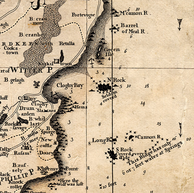
So maybe the poem reference to Cloughey Bay is a bit of storytellers creative licence, but I am open to further information on this if any readers can affirm. Here is a detail from the famous Dr Kennedy's 1755 A Map of the County of Down with a Chart of ye Sea Coast done from Actual Surveys and Accurate Observations:
But the rocks on the coastline weren't the only things that were treacherous...
• A list from 1756: "our most treacherous enemies the French"
This apparent pro-French alliance on the Ards Peninsula was a volte-face from 40 years earlier - on 13 April 1756 the Belfast News-Letter published A petition from the inhabitants of Ballywalter and Ballyhalbert in response to the threat of danger from "our most treacherous enemies the French", with a list of 78 men who had put their names to it. The next month the French would invade Minorca, beginning the Seven Years War – so Millisle was probably on their list too (Wikipedia here).
No Thompsons are named on the petition, but they weren't living at Ballyhalbert or Ballywalter anyway. It was around the 1750s when my Ayrshire Thompson ancestors came across the narrow sea and settled at Ratallagh (marked on the map as Retalla) at the north end of Cloughey Bay.
Of course, France had undergone its revolution within those decades between 1756 and 1797. The world had changed. But, as ever, it's important to not presume top-down concepts of nationality. Bottom-up community is where the authentic and interesting is to be found, and where apparent paradoxes can be better explained.
0 comments:
Post a Comment